We were due to get up at 5:30am today to walk the Tongariro Alpine Crossing, however neither of us could get to sleep so we got up at 2:30am instead and watched Swimfan (on the one channel in New Zealand that still operates at that hour) before having just a big enough nap to be irritable once the alarm finally went off. A bus collected us from central Turangi and – after a strange briefing from the driver, in which she explained this was really quite an ugly place to walk – dropped us off at the start of what is widely regarded as the best one day trek in the country. About two hundred other people also appeared to be doing the walk, but once we got going we all distributed out nicely along the path. We saw plenty of people on route, but it wasn't so packed you could start a conga.
The walk started at the foot of Mount Ngauruhoe, a huge conical volcano which is now better known as 'Mount Doom', thanks in part to Sir Peter Jackson using it in his popular series of hobbit movies but mostly because no one really knows how to pronounce 'Ngauruhoe'. The sun was still low in the sky, so this part of the walk was relatively cool and we enjoyed an easy hour's hike through the volcanic wastelands, crossing old lava flows and following a soda stream up to the base of the volcano.

The track then turned abruptly uphill, up what the guidebook referred to as the Devil's Staircase. I'd expected this to be a natural formation – say, layers of limestone lying in fractured strata to form a natural flight of steps up the mountain – but it transpired to be just a series of man-made pine staircases which looked no more than ten years old, winding their way up the side of the mountain. This was all a bit blah, although as we climbed higher we were rewarded with stunning views out across the North Island, including lakes, forests, meadows and a very distant snow-topped mountain.
There was an option here to ascend Mount Doom itself, however that track is not really defined and our guidebook contained a series of warnings to the effect that climbing the volcano is an act of suicide (and requires long trousers) so we dismissed the idea. There was also a sign which advised on the correct course of action should Mount Doom start to erupt. Most of these involved advice along the lines of “Try not to let any flying rocks hit your head” and “Try not to get engulfed in a sudden lava flow”, so I suspect there wasn't really anything we would be able to do if it did explode.

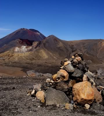
We crossed a ridge, descended into the South Crater and then crossed the flattest terrain I have ever walked across, which was so flat it confused my brain into thinking we were walking on water. The crater appears to have been filled with clay and then perfectly levelled off, and while this might sound quite dull we did get some superb views of Mount Doom, which was far more colourful from this angle and appears to be topped in rich deep red.

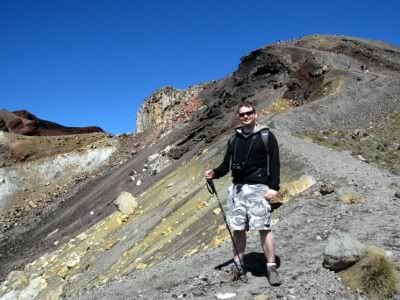
Also looming on the horizon was the Red Crater ridge, which I particularly feared as the guidebook warned that the track there follows a narrow ridge with long drops on either side. We first climbed up to the top of the ridge where we found a stunningly desolate wasteland on the other side, with volcanic rock formations even more twisted and bizarre than during our initial walk from the drop-off point. We then followed the track along the top of the ridge, which was quite very scary and whenever I slipped and lost my footing I figured I was a goner. When we got to the top at 1886 metres – and enjoyed our sandwiches overlooking stunning views of the way we had come – I was justifiably very proud of myself.

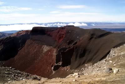
Alas, it transpired that wasn't actually not the scary part of the Red Crater Ridge. After a cheese and jam sandwich we followed the route towards the Red Crater proper and I was confused to see that the path suddenly stopped. As we reached that point I saw why: a couple of feet in front of me was a sheer drop down into the heart of the active volcanic crater, with the pathway skirting left along the lip of the crater (I was petrified, but I postponed hysteria sufficiently to observe that the crater was an unexpected and breathtaking shade of red, cross-cut with bands of black volcanic rock). The guidebook here had a wonderful piece of advice: “Please do not walk too close to the edge of the crater because if you fall in you will not come out.” If this were the UK, they would have ten foot high fences around this sort of hazard – but then, if they did that it wouldn't be worth coming to see.

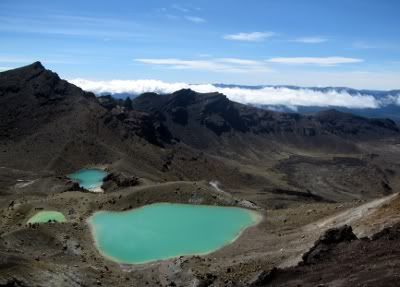
I focussed my mind on survival and marched up the ridge and back down the other side. The path on the far side was about two metres wide with sheer drops on either side, but worse was made from a sort of volcanic sand and scree which slipped from under you as you walked. Everyone slipped and slid down the ridge, but surprisingly no one toppled off into the volcano and died. Looking back you could see into the rich red heart of the crater, while down below sat the Emerald Lakes, a group of fabulous blue ponds. The eggy stench of sulphur was thick in the air so we assume the ponds were filled with sulphuric acid, although the guidebook only offered the hint “No swimming!”

We trekked down through the flats of the vast Central Crater and then climbed up the ridge on the far side. We were supposed to be admiring the Blue Lake (“No swimming!”) here, but in the opposite direction was the much more beautiful view of the vivid red crater snuggling up against the red-tipped Mount Doom.
It was all down hill from here, in every sense. We endured a long and tedious trek down through the grassy hills of the Rotopaunga Valley into a winding pathway through bland forests which seemed to last absolutely forever (but was in fact only two and a half hours). Despite this, seeing Mount Doom and the Red Crater so close up is definitely yet another Top Ten highlight of the holiday, our pleasure only marginally diluted by the return journey. This was the closest we've been to the heart of an active volcano and we were surprised by how beautiful something so desolate and destructive could be. Although this was called the Tongariro Crossing we didn't actually notice Mount Tongariro at all. It wasn't any particular colour and didn't belch smoke or threaten to erupt, and so went pretty much unnoticed.

We had planned a big dinner with champagne when we got home, but were too tired and dehydrated so we only had toast and champagne, and then bed.


Dude, jolly well done on facing that terror! Also, in that first photo of you you're looking - I must say - rather ripped. Insect swatting apparently really buffs those pecs.
ReplyDeleteWow, that's fantastic! What an amazing place. It's great you faced that fear - will rope bridges be next?
ReplyDeleteGlad you're back - internet in return for frittata is a great deal.
Haven't you filled your Top Ten quota yet?? It all looks absolutely stunning. Good to see you didn't drop the champagne part of your meal.
ReplyDelete